| 来源类型 | Brochures and Factsheets |
| 规范类型 | 其他 |
| WFP Mali - Satellite Imagery | |
| [unavailable] | |
| 发表日期 | 2020-05-18 |
| 出版年 | 2020 |
| 语种 | 英语 |
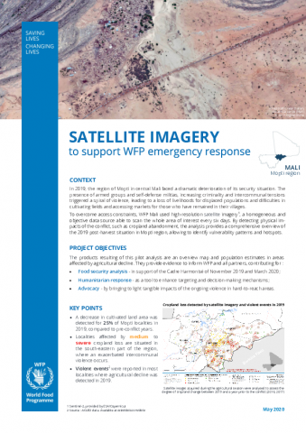
| 摘要 | The past decade has witnessed a boom in the availability of satellite data whether from established space agencies or from the private sector. Unique in their ability to screen the entire Earth, satellites provide timely and objective data at a variety of spatial and temporal scales. In doing so, it can address a broad range of applications - e.g. agricultural monitoring, early warning of droughts, flood damage assessment, conflict and population dynamics monitoring, urban food security assessments. The increase in the types of satellite-derived information comes at a critical time for WFP. The organization is facing a number of interconnected, global or regional scale challenges such as natural disasters, widespread conflict, population movements or impacts of climate change. To help meet the consequent spiraling increase in information requirements, Earth Observation (EO) has become a mainstay of WFP analytical work since 2010 and is currently used for a number of operational activities, among which seasonal monitoring, crop type mapping or monitoring asset creation activities. This document presents how WFP Mali used Earth Observation data in hard-to-reach areas to overcome access constraints and territory vastness. By detecting cropland abandonment in 2019 across the region of Mopti, this pilot study enabled to identify affected localities and to assess physical impacts of the widespread conflict. The triangulation with insecurity data underscores a clear correlation between agricultural decline and reported violent events. Eventually, this study describes how such satellite-derived products were used in the operational context of Mali. |
| 主题 | Emergencies ; Mali |
| 区域 | Mali |
| URL | https://www.wfp.org/publications/wfp-mali-satellite-imagery |
| 来源智库 | World Food Programme (Italy) |
| 资源类型 | 智库出版物 |
| 条目标识符 | http://119.78.100.153/handle/2XGU8XDN/521277 |
| 推荐引用方式 GB/T 7714 | [unavailable]. WFP Mali - Satellite Imagery. 2020. |
| 个性服务 |
| 推荐该条目 |
| 保存到收藏夹 |
| 导出为Endnote文件 |
| 谷歌学术 |
| 谷歌学术中相似的文章 |
| [[unavailable]]的文章 |
| 百度学术 |
| 百度学术中相似的文章 |
| [[unavailable]]的文章 |
| 必应学术 |
| 必应学术中相似的文章 |
| [[unavailable]]的文章 |
| 相关权益政策 |
| 暂无数据 |
| 收藏/分享 |


| 文件名: | ea239525bcd70762a2e1c6729f927832.png |
| 格式: | image/png |
除非特别说明,本系统中所有内容都受版权保护,并保留所有权利。


